|
| ||||||||||||||||||||
ad

|

|

|

|
||
Right Up Corner
 |
วันพฤหัสบดีที่ 1 กันยายน พ.ศ. 2565


วัดบนเขา Meteora กรีก Greece
ที่มา http://en.wikipedia.org/wiki/Meteora


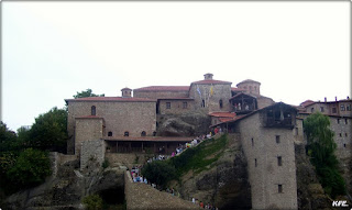


The Metéora (Greek: Μετέωρα, "suspended rocks", "suspended in the air" or "in the heavens above" - etymologically similar to "Meteorite") is one of the largest and most important complexes of Eastern Orthodox monasteries in Greece, second only to Mount Athos.[1] The six monasteries are built on natural sandstone rock pillars, at the northwestern edge of the Plain of Thessaly near the Pineios river and Pindus Mountains, in central Greece. The nearest town is Kalambaka. The Metéora is included on the UNESCO World Heritage List under criteria[2] I, II, IV, V and VII.[3]
แปลโดย translate.google.com
Meteora (กรีก : Μετέωρα,"ระงับหิน","แขวนลอยในอากาศ"หรือ"ในชั้นฟ้าทั้งหลายข้างต้น"-- etymologically คล้ายกับ"อุกกาบาต") เป็นหนึ่งในคอมเพล็กซ์ที่ใหญ่ที่สุดและสำคัญที่สุดของภาคตะวันออกวัดดั้งเดิมในกรีซที่สอง เท่านั้นที่จะ Mount Athos. [1] หกวัดที่สร้างขึ้นบนเสาหินหินทรายธรรมชาติที่ขอบตะวันตกเฉียงเหนือของธรรมดาของ Thessaly ใกล้ Pineios แม่น้ำและภูเขา Pindus, ในภาคกลางของกรีซ เมืองที่ใกล้ที่สุดอยู่ Kalambaka Meteora จะรวมอยู่ในรายชื่อมรดกโลกภายใต้เกณฑ์ [2] I, II, IV, V และ VII. [3]
In the 9th century, an ascetic group of hermit monks moved up to the ancient pinnacles.
They were the first people to inhabit Metéora. They lived in hollows and fissures in the rock towers, some of which reach 1800 ft (550m) above the plain. This great height, combined with the sheerness of the cliff walls, kept away all but the most determined visitors. Initially the hermits led a life of solitude, meeting only on Sundays and special days to worship and pray in a chapel built at the foot of a rock known as Dhoupiani. As early as the 11th century AD hermit monks were believed to be living among the caves and cutouts in the rocks.[1]
The exact date of the establishment of the monasteries is unknown. By the late 11th and early 12th century, a rudimentary monastic state had formed called the Skete of Stagoi and was centered around the still-standing church of Theotokos (mother of God).[1] By the end of the 12th century, an ascetic community had flocked to Metéora.
In 1344, Athanasios Koinovitis from Mount Athos brought a group of followers to Metéora. From 1356 to 1372, he founded the great Meteoron monastery on Broad Rock, which were perfect for the monks; they were safe from political upheaval and had complete control of the entry to the monastery. The only means of reaching it was by climbing a long ladder, which was drawn up whenever the monks felt threatened.
At the end of the 14th century, the Byzantine Empire's 800-year reign over northern Greece was being increasingly threatened by Turkish raiders who wanted control over the fertile plain of Thessaly. The hermit monks, seeking a retreat from the expanding Turkish occupation, found the inaccessible rock pillars of Meteora to be an ideal refuge. More than 20 monasteries were built, beginning in the 14th century.[1] Six remain today. There is a common belief that St. Athanasius (founder of the first monastery) did not scale the rock, but was carried there by an eagle.[4]
In 1517, Nectarios and Theophanes built the monastery of Varlaám, which was reputed to house the finger of St John and the shoulder blade of St Andrew.
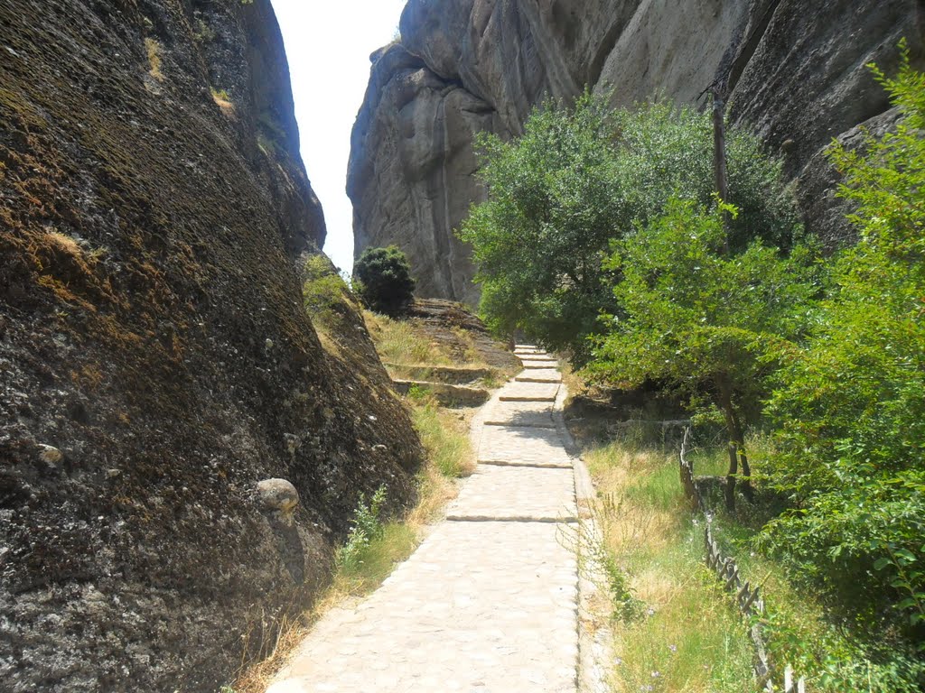
Access to the monasteries was originally (and deliberately) difficult, requiring either long ladders lashed together or large nets used to haul up both goods and people. This required quite a leap of faith – the ropes were replaced, so the story goes, only "when the Lord let them break".[5] In the words of UNESCO, "The net in which intrepid pilgrims were hoisted up vertically alongside the 373 metres (1,224 ft) cliff where the Varlaam monastery dominates the valley symbolizes the fragility of a traditional way of life that is threatened with extinction."[6] In the 1920s there was an improvement in the arrangements. Steps were cut into the rock, making the complex accessible via a bridge from the nearby plateau. During World War II the site was bombed and many art treasures were stolen.
Until the 17th century, the primary means of conveying goods and people from these eyries was by means of baskets and ropes.[7]
Only six of the monasteries remain today.[6] Of these six, four were inhabited by men, and two by women. Each monastery has fewer than 10 inhabitants. The monasteries are now tourist attractions.
แปลโดย translate.google.com
ประวัติ
Theopetra ถ้ำ 5 กิโลเมตร (3.1 ไมล์) ใต้ของ Meteora มีห้าสิบคนที่อาศัยอยู่นับพันปีที่ผ่านมา ถ้ำ Theopetra, Kalambaka, หลักฐาน radiocarbon 50,000 ปีของการแสดงตนของมนุษย์, 43 Radiocarbon (2B). 1029-1048 [อ้างจำเป็น] [ชี้แจงจำเป็น]
ในศตวรรษที่ 9, กลุ่มที่สันโดษของพระฤาษีย้ายขึ้นไปที่ Pinnacles โบราณ
พวกเขาเป็นคนแรกที่อาศัยอยู่ใน Meteora พวกเขาอาศัยอยู่ใน hollows และรอยแยกในอาคารหินซึ่งบางส่วนถึง 1,800 ฟุต (550M) ข้างต้นล้วน นี้สูงมากรวมกับความตรงของผนังหน้าผาเก็บไว้ออกไปทั้งหมด แต่ส่วนใหญ่ผู้เข้าชมกำหนด เริ่ม Hermits ที่นำชีวิตของสันโดษประชุมเฉพาะวันอาทิตย์และวันที่พิเศษไปนมัสการและ อธิษฐานในโบสถ์ที่สร้างขึ้นที่เท้าของหินที่รู้จักกันเป็น Dhoupiani ที่ เป็นช่วงต้นของศตวรรษที่พระฤาษี AD ที่ 11 ถูกเชื่อว่าจะมีชีวิตในถ้ำและ cutouts ในหิน. [1]
วันที่ที่แน่นอนของการจัดตั้งวัดไม่เป็นที่รู้จัก โดย ปลายศตวรรษที่ 12 และต้น 11 รัฐสงฆ์ขั้นปฐมได้เกิดจากการที่เรียกว่า Skete Stagoi และเป็นศูนย์กลางรอบโบสถ์ที่ยังคงยืน Theotokos (แม่ของพระเจ้า). [1] ในตอนท้ายของศตวรรษที่ 12, สันโดษ ชุมชนมี flocked เพื่อ Meteora
ใน 1344, Athanasios Koinovitis จาก Mount Athos นำกลุ่มลูกศิษย์ของเพื่อ Meteora เริ่มต้น ที่ 1356-1372 เขาได้ก่อตั้งอาราม Meteoron ที่ดีเกี่ยวกับ Rock กว้างซึ่งเหมาะสำหรับพระสงฆ์; พวกเขาปลอดภัยจากการเปลี่ยนแปลงขนาดใหญ่ทางการเมืองและมีการควบคุมที่ สมบูรณ์ของรายการที่วัด หมายถึงเฉพาะการเข้าถึงมันเป็นบันไดปีนเขายาวซึ่งถูกวาดขึ้นเมื่อใดก็ตามที่พระสงฆ์รู้สึกถูกคุกคาม
ใน ตอนท้ายของศตวรรษที่ 14, 800 - รัชสมัยปีที่ไบเซนไทน์เอ็มไพร์กว่าทางตอนเหนือของกรีซที่ถูกคุกคามมากขึ้น โดย Raiders ตุรกีผู้ที่ต้องการควบคุมมากกว่าธรรมดาอุดมสมบูรณ์ของ Thessaly พระ ฤาษีกำลังมองหาสถานที่พักผ่อนจากการประกอบอาชีพของตุรกีขยายตัวพบเสาหินที่ ไม่สามารถเข้าถึงได้ของ Meteora ที่จะเป็นที่หลบภัยที่เหมาะ กว่า 20 วัดถูกสร้างขึ้น, จุดเริ่มต้นในศตวรรษที่ 14. [1] วันนี้ยังคงอยู่ที่หก มีความเชื่อกันว่าเซนต์ Athanasius (ผู้ก่อตั้งวัดแรก) ไม่ได้ขนาดหินที่มี แต่ได้ดำเนินการโดยมีนกอินทรี. [4]
ใน 1517, Nectarios และ Theophanes สร้างวัดของ Varlaám ซึ่งเป็นที่เลื่องลือไปที่บ้านของลายนิ้วมือของ St John และใบไหล่ของ St Andrew
การ เข้าถึงวัดนี้ แต่เดิม (และเจตนา) เรื่องยากที่ต้องใช้ทั้งบันไดยาว lashed กันหรือตาข่ายขนาดใหญ่ที่ใช้ในการลากขึ้นทั้งสินค้าและผู้คน นี้ จำเป็นต้องมีค่อนข้างก้าวกระโดดของความเชื่อ -- เชือกถูกแทนที่ดังนั้นเรื่องราวที่จะไปเท่านั้น"เมื่อพระเจ้าทรงให้พวกเขา ทำลาย"[5] ในคำพูดของยูเนสโก,"สุทธิที่กล้าหาญผู้แสวงบุญถูก hoisted ขึ้นตรงข้าง. 373 เมตร (1,224 ฟุต) หน้าผาที่พระอาราม Varlaam dominates หุบเขาเป็นสัญลักษณ์ของความเปราะบางของวิธีการดั้งเดิมของชีวิตที่ถูกคุกคาม ด้วยการสูญพันธุ์."[6] ในปี ค.ศ. 1920 มีการปรับปรุงในการเตรียม ขั้นตอนที่ถูกตัดเป็นก้อนหินที่ทำให้มีความซับซ้อนเข้าถึงได้ผ่านทางสะพานที่เชื่อมจากที่ราบสูงในบริเวณใกล้เคียง ในช่วงสงครามโลกครั้งเว็บไซต์ที่ถูกทิ้งระเบิดและสมบัติศิลปะจำนวนมากถูกขโมย
จนกระทั่งศตวรรษที่ 17 หมายถึงหลักของการลำเลียงสินค้าและผู้คนจาก eyries เหล่านี้ได้โดยความหมายของกระเช้าและเชือก. [7]
เพียงหกของพระราชวงศ์ยังคงอยู่ในวันนี้. [6] ของเหล่านี้หกสี่ที่อาศัยอยู่โดยมีผู้ชายและผู้หญิงสอง พระอารามแต่ละคนมีน้อยกว่า 10 คน วัดอยู่ในขณะนี้สถานที่ท่องเที่ยว
แผนที่
View วัดบนเขา Meteora in a larger map


The Metéora (Greek: Μετέωρα, "suspended rocks", "suspended in the air" or "in the heavens above" - etymologically similar to "Meteorite") is one of the largest and most important complexes of Eastern Orthodox monasteries in Greece, second only to Mount Athos.[1] The six monasteries are built on natural sandstone rock pillars, at the northwestern edge of the Plain of Thessaly near the Pineios river and Pindus Mountains, in central Greece. The nearest town is Kalambaka. The Metéora is included on the UNESCO World Heritage List under criteria[2] I, II, IV, V and VII.[3]
แปลโดย translate.google.com
Meteora (กรีก : Μετέωρα,"ระงับหิน","แขวนลอยในอากาศ"หรือ"ในชั้นฟ้าทั้งหลายข้างต้น"-- etymologically คล้ายกับ"อุกกาบาต") เป็นหนึ่งในคอมเพล็กซ์ที่ใหญ่ที่สุดและสำคัญที่สุดของภาคตะวันออกวัดดั้งเดิมในกรีซที่สอง เท่านั้นที่จะ Mount Athos. [1] หกวัดที่สร้างขึ้นบนเสาหินหินทรายธรรมชาติที่ขอบตะวันตกเฉียงเหนือของธรรมดาของ Thessaly ใกล้ Pineios แม่น้ำและภูเขา Pindus, ในภาคกลางของกรีซ เมืองที่ใกล้ที่สุดอยู่ Kalambaka Meteora จะรวมอยู่ในรายชื่อมรดกโลกภายใต้เกณฑ์ [2] I, II, IV, V และ VII. [3]
History
The Theopetra caves 5 kilometres (3.1 mi) south of Meteora had inhabitants fifty millennia ago. The cave of Theopetra, Kalambaka, radiocarbon evidence for 50,000 years of human presence, Radiocarbon 43(2B): 1029-1048.[citation needed][clarification needed]In the 9th century, an ascetic group of hermit monks moved up to the ancient pinnacles.
They were the first people to inhabit Metéora. They lived in hollows and fissures in the rock towers, some of which reach 1800 ft (550m) above the plain. This great height, combined with the sheerness of the cliff walls, kept away all but the most determined visitors. Initially the hermits led a life of solitude, meeting only on Sundays and special days to worship and pray in a chapel built at the foot of a rock known as Dhoupiani. As early as the 11th century AD hermit monks were believed to be living among the caves and cutouts in the rocks.[1]
The exact date of the establishment of the monasteries is unknown. By the late 11th and early 12th century, a rudimentary monastic state had formed called the Skete of Stagoi and was centered around the still-standing church of Theotokos (mother of God).[1] By the end of the 12th century, an ascetic community had flocked to Metéora.
In 1344, Athanasios Koinovitis from Mount Athos brought a group of followers to Metéora. From 1356 to 1372, he founded the great Meteoron monastery on Broad Rock, which were perfect for the monks; they were safe from political upheaval and had complete control of the entry to the monastery. The only means of reaching it was by climbing a long ladder, which was drawn up whenever the monks felt threatened.
At the end of the 14th century, the Byzantine Empire's 800-year reign over northern Greece was being increasingly threatened by Turkish raiders who wanted control over the fertile plain of Thessaly. The hermit monks, seeking a retreat from the expanding Turkish occupation, found the inaccessible rock pillars of Meteora to be an ideal refuge. More than 20 monasteries were built, beginning in the 14th century.[1] Six remain today. There is a common belief that St. Athanasius (founder of the first monastery) did not scale the rock, but was carried there by an eagle.[4]
In 1517, Nectarios and Theophanes built the monastery of Varlaám, which was reputed to house the finger of St John and the shoulder blade of St Andrew.
Access to the monasteries was originally (and deliberately) difficult, requiring either long ladders lashed together or large nets used to haul up both goods and people. This required quite a leap of faith – the ropes were replaced, so the story goes, only "when the Lord let them break".[5] In the words of UNESCO, "The net in which intrepid pilgrims were hoisted up vertically alongside the 373 metres (1,224 ft) cliff where the Varlaam monastery dominates the valley symbolizes the fragility of a traditional way of life that is threatened with extinction."[6] In the 1920s there was an improvement in the arrangements. Steps were cut into the rock, making the complex accessible via a bridge from the nearby plateau. During World War II the site was bombed and many art treasures were stolen.
Until the 17th century, the primary means of conveying goods and people from these eyries was by means of baskets and ropes.[7]
Only six of the monasteries remain today.[6] Of these six, four were inhabited by men, and two by women. Each monastery has fewer than 10 inhabitants. The monasteries are now tourist attractions.
แปลโดย translate.google.com
ประวัติ
Theopetra ถ้ำ 5 กิโลเมตร (3.1 ไมล์) ใต้ของ Meteora มีห้าสิบคนที่อาศัยอยู่นับพันปีที่ผ่านมา ถ้ำ Theopetra, Kalambaka, หลักฐาน radiocarbon 50,000 ปีของการแสดงตนของมนุษย์, 43 Radiocarbon (2B). 1029-1048 [อ้างจำเป็น] [ชี้แจงจำเป็น]
ในศตวรรษที่ 9, กลุ่มที่สันโดษของพระฤาษีย้ายขึ้นไปที่ Pinnacles โบราณ
พวกเขาเป็นคนแรกที่อาศัยอยู่ใน Meteora พวกเขาอาศัยอยู่ใน hollows และรอยแยกในอาคารหินซึ่งบางส่วนถึง 1,800 ฟุต (550M) ข้างต้นล้วน นี้สูงมากรวมกับความตรงของผนังหน้าผาเก็บไว้ออกไปทั้งหมด แต่ส่วนใหญ่ผู้เข้าชมกำหนด เริ่ม Hermits ที่นำชีวิตของสันโดษประชุมเฉพาะวันอาทิตย์และวันที่พิเศษไปนมัสการและ อธิษฐานในโบสถ์ที่สร้างขึ้นที่เท้าของหินที่รู้จักกันเป็น Dhoupiani ที่ เป็นช่วงต้นของศตวรรษที่พระฤาษี AD ที่ 11 ถูกเชื่อว่าจะมีชีวิตในถ้ำและ cutouts ในหิน. [1]
วันที่ที่แน่นอนของการจัดตั้งวัดไม่เป็นที่รู้จัก โดย ปลายศตวรรษที่ 12 และต้น 11 รัฐสงฆ์ขั้นปฐมได้เกิดจากการที่เรียกว่า Skete Stagoi และเป็นศูนย์กลางรอบโบสถ์ที่ยังคงยืน Theotokos (แม่ของพระเจ้า). [1] ในตอนท้ายของศตวรรษที่ 12, สันโดษ ชุมชนมี flocked เพื่อ Meteora
ใน 1344, Athanasios Koinovitis จาก Mount Athos นำกลุ่มลูกศิษย์ของเพื่อ Meteora เริ่มต้น ที่ 1356-1372 เขาได้ก่อตั้งอาราม Meteoron ที่ดีเกี่ยวกับ Rock กว้างซึ่งเหมาะสำหรับพระสงฆ์; พวกเขาปลอดภัยจากการเปลี่ยนแปลงขนาดใหญ่ทางการเมืองและมีการควบคุมที่ สมบูรณ์ของรายการที่วัด หมายถึงเฉพาะการเข้าถึงมันเป็นบันไดปีนเขายาวซึ่งถูกวาดขึ้นเมื่อใดก็ตามที่พระสงฆ์รู้สึกถูกคุกคาม
ใน ตอนท้ายของศตวรรษที่ 14, 800 - รัชสมัยปีที่ไบเซนไทน์เอ็มไพร์กว่าทางตอนเหนือของกรีซที่ถูกคุกคามมากขึ้น โดย Raiders ตุรกีผู้ที่ต้องการควบคุมมากกว่าธรรมดาอุดมสมบูรณ์ของ Thessaly พระ ฤาษีกำลังมองหาสถานที่พักผ่อนจากการประกอบอาชีพของตุรกีขยายตัวพบเสาหินที่ ไม่สามารถเข้าถึงได้ของ Meteora ที่จะเป็นที่หลบภัยที่เหมาะ กว่า 20 วัดถูกสร้างขึ้น, จุดเริ่มต้นในศตวรรษที่ 14. [1] วันนี้ยังคงอยู่ที่หก มีความเชื่อกันว่าเซนต์ Athanasius (ผู้ก่อตั้งวัดแรก) ไม่ได้ขนาดหินที่มี แต่ได้ดำเนินการโดยมีนกอินทรี. [4]
ใน 1517, Nectarios และ Theophanes สร้างวัดของ Varlaám ซึ่งเป็นที่เลื่องลือไปที่บ้านของลายนิ้วมือของ St John และใบไหล่ของ St Andrew
การ เข้าถึงวัดนี้ แต่เดิม (และเจตนา) เรื่องยากที่ต้องใช้ทั้งบันไดยาว lashed กันหรือตาข่ายขนาดใหญ่ที่ใช้ในการลากขึ้นทั้งสินค้าและผู้คน นี้ จำเป็นต้องมีค่อนข้างก้าวกระโดดของความเชื่อ -- เชือกถูกแทนที่ดังนั้นเรื่องราวที่จะไปเท่านั้น"เมื่อพระเจ้าทรงให้พวกเขา ทำลาย"[5] ในคำพูดของยูเนสโก,"สุทธิที่กล้าหาญผู้แสวงบุญถูก hoisted ขึ้นตรงข้าง. 373 เมตร (1,224 ฟุต) หน้าผาที่พระอาราม Varlaam dominates หุบเขาเป็นสัญลักษณ์ของความเปราะบางของวิธีการดั้งเดิมของชีวิตที่ถูกคุกคาม ด้วยการสูญพันธุ์."[6] ในปี ค.ศ. 1920 มีการปรับปรุงในการเตรียม ขั้นตอนที่ถูกตัดเป็นก้อนหินที่ทำให้มีความซับซ้อนเข้าถึงได้ผ่านทางสะพานที่เชื่อมจากที่ราบสูงในบริเวณใกล้เคียง ในช่วงสงครามโลกครั้งเว็บไซต์ที่ถูกทิ้งระเบิดและสมบัติศิลปะจำนวนมากถูกขโมย
จนกระทั่งศตวรรษที่ 17 หมายถึงหลักของการลำเลียงสินค้าและผู้คนจาก eyries เหล่านี้ได้โดยความหมายของกระเช้าและเชือก. [7]
เพียงหกของพระราชวงศ์ยังคงอยู่ในวันนี้. [6] ของเหล่านี้หกสี่ที่อาศัยอยู่โดยมีผู้ชายและผู้หญิงสอง พระอารามแต่ละคนมีน้อยกว่า 10 คน วัดอยู่ในขณะนี้สถานที่ท่องเที่ยว
แผนที่
View วัดบนเขา Meteora in a larger map


สมัครสมาชิก:
บทความ (Atom)
BumQ